Knowledge

State-of-the-art seabed habitat mapping

Dr Tim Jackson-Bué, Senior Habitat Mapping Specialist at Ocean Ecology

May 15, 2025

Beneath our seas lie a diverse array of seabed habitats shaped by physical and biological processes. To operate sustainably, it is essential for our marine industry partners to understand the seabed habitats their work interacts with, and a critical part of building this knowledge is habitat mapping.

At Ocean Ecology we use state-of-the art techniques to deliver accurate and efficient seabed habitat mapping solutions.

Why habitat mapping matters

Unlike terrestrial habitats that can be photographed from the air or space, marine habitats can often only be observed with close-range imagery from a seabed camera or by collecting samples of sediment with a grab. To build up a complete seabed map, these fine-scale observations can be used to interpret patterns in broad-scale data from other sources, like bathymetry from acoustic sensors.

Seabed habitat mapping has long relied on manual interpretation, with experts examining all the available data and using their experience to meticulously identify regions of different habitats. However, advances in sensor technology and processing methods now mean that some of the more time-consuming stages can be achieved more efficiently and effectively with automation.

Harnessing machine learning for mapping

We work with clients to develop bespoke semi-automated seabed mapping solutions for a wide range of projects to produce accurate results and accelerate reporting timeframes. We apply advanced machine learning models, such as Random Forest and XGBoost, to detect complex patterns in acoustic, visual and environmental datasets that are beyond the capabilities of human interpretation.

Picture of a seabed habitat map
A subtidal habitat map generated using machine learning

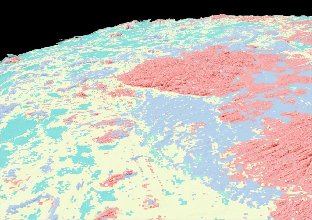
As we continue to advance at the cutting edge of technology, we are incorporating deep learning methods into our mapping processes. With machine-learning-driven approaches, we can rapidly produce statistically robust habitat predictions across large areas of seabed, for quantified, repeatable results. Expert interpretation remains essential to tune and supervise the modelling process, ensuring the final map products are of the highest quality and confidence.

Our advanced seabed mapping and modelling techniques support a broad range of our services including environmental baseline surveys, habitat assessments, site characterisation and monitoring. In recent months we have employed these methods to improve and accelerate deliverables in both subtidal and intertidal habitat mapping for projects including offshore windfarms, undersea cables and pipelines, and marine protected area assessments.

Real-World Impact: Subsea Cable Case Study

A recent project in which we were tasked with mapping habitats for a proposed subsea cable demonstrates the benefits of our semi-automated mapping routines.

Picture showing the transition from aerial photograph to habitat map
Habitat maps are composed of different data layers that visualise the shore or seabed. This image starts on the left with an aerial UAV image, and transitions through layers of image segmentation, elevation model, terrain derivatives, machine learning output, and ends with the human-supervised habitat map on the right-hand side.

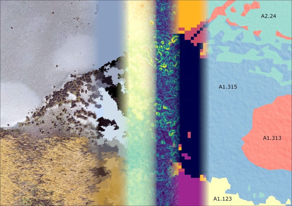
The study area encompassed both subtidal and intertidal zones, featuring a complex mosaic of substrates and habitats – including some protected under conservation legislation.

We used object based image analysis and XGBoost models to rapidly predict the spatial distribution of habitats by integrating acoustic, drone and in-situ sampling data. After generating modelled predictions, habitat mapping specialists used the results as a basis for a quality-controlled interpretation and GIS specialists generated a set of final map products. The process proved to be highly efficient and effective compared to a traditional approach of manually digitising all individual habitat boundaries.

Picture of Dr Tim Jackson-Bue

Dr Tim Jackson-Bué, Senior Habitat Mapping Specialist at Ocean Ecology

Tim Jackson-Bué joined Ocean Ecology in 2024 and has a PhD in marine ecology and habitat mapping as well as extensive experience working with industry partners.

related articles

Aerial picture of a salmon farm in the sea close to the shore

Knowledge

Sharing Scottish veterinarians' experiences in fish health with Iceland
Read article: Sharing Scottish veterinarians’ experiences in fish health with Iceland
Picture of Ocean Ecology's Freshwater lens camera system ready to be deployed over the side of a boat

Knowledge

Seeing through the murk: how freshwater housing camera systems can improve benthic surveys in low-visibility marine environments
Read article: Seeing through the murk: how freshwater housing camera systems can improve benthic surveys in low-visibility marine environments
Picture of two scientists working in an eDNA laboratory

Knowledge

The benefits of eDNA analysis
Read article: The benefits of eDNA analysis
Picture of exposed Sabellaria reef on a seashore

Knowledge

Exploring the seafloor with acoustic cameras: a closer look at Sabellaria spinulosa reefs

Read article: Exploring the seafloor with acoustic cameras: a closer look at Sabellaria spinulosa reefs
Benthic pic for MRO news story

News

First tranche of data migrated to Marine Recorder Online
Read article: First tranche of data migrated to Marine Recorder Online
Picture of a fish farm in calm seas at dusk

Knowledge

Looking ahead to 2030: strengthening aquaculture for a sustainable blue economy
Read article: Looking ahead to 2030: strengthening aquaculture for a sustainable blue economy
Picture of a group of salmon in a fish farm

Knowledge

Aquaculture, benthic compliance and the IQI
Read article: Aquaculture, benthic compliance and the IQI
Picture of Sabellaria spinulosa reef

Knowledge

Sabellaria spinulosa reef: a geophysical review

Read article: Sabellaria spinulosa reef: a geophysical review
Josh Australia article 1, April 2025

News

Ocean Ecology expands into Australia and the APAC region under DNV
Read article: Ocean Ecology expands into Australia and the APAC region under DNV
Aerial picture of a salmon farm in the sea close to the shore

Knowledge

Sharing Scottish veterinarians' experiences in fish health with Iceland
Read article: Sharing Scottish veterinarians’ experiences in fish health with Iceland
Picture of two marine mammal observers looking out to sea through binoculars

News

Secure OceanConnect portal streamlines sub-contractor management
Read article: Secure OceanConnect portal streamlines sub-contractor management
Picture of Ocean Ecology's Freshwater lens camera system ready to be deployed over the side of a boat

Knowledge

Seeing through the murk: how freshwater housing camera systems can improve benthic surveys in low-visibility marine environments
Read article: Seeing through the murk: how freshwater housing camera systems can improve benthic surveys in low-visibility marine environments

related projects

Picture of three whale fins breaking the surface of the ocean
Oil & Gas
Marine mammal mitigation during seismic surveys close to western gray whale feeding grounds
Visit project page: Marine mammal mitigation during seismic surveys close to western gray whale feeding grounds
Picture of survey crew deploying a grab over the side of a vessel at sea
Oil & Gas
Delivering full-service environmental survey for southern North Sea decommissioning
Visit project page: Delivering full-service environmental survey for southern North Sea decommissioning
Aerial picture of the rocky shore in the survey area
Offshore Wind
Spiorad na Mara Offshore Wind Farm Environmental Surveys
Visit project page: Spiorad na Mara Offshore Wind Farm Environmental Surveys
Picture of dolphins in the Celtic Sea
Offshore Wind
Celtic Sea pre-consenting survey: marine mammal and seabird observations
Visit project page: Celtic Sea pre-consenting survey: marine mammal and seabird observations
Picture of two survey team holding a dogfish landed in the survey at Allonby Bay
Regulatory Bodies
Fish survey helps understand the ecology of Allonby Bay HPMA
Visit project page: Fish survey helps understand the ecology of Allonby Bay HPMA
Picture of a survey crew member working on the boat at sunrise
Offshore Wind
Sofia Offshore Wind Farm: Pre-Construction Benthic Survey and Advisory Services
Visit project page: Sofia Offshore Wind Farm: Pre-Construction Benthic Survey and Advisory Services
Picture of crew members preparing to launch a grab over the side of the boat
Offshore Wind
Bellrock and Broadshore Offshore Wind Farms, environmental surveys
Visit project page: Bellrock and Broadshore Offshore Wind Farms, environmental surveys
Picture of the sunset over the North Atlantic
Research
M201 Iceland to Azores Research Cruise, marine mammal mitigation
Visit project page: M201 Iceland to Azores Research Cruise, marine mammal mitigation
Picture of a turtle swimming beside the survey boat
Research
M199 Sicily Research Cruise, marine mammal mitigation
Visit project page: M199 Sicily Research Cruise, marine mammal mitigation
Satellite image of the Solent showing points where the oyster restoration project would focus
Aquaculture
Solent Oyster Restoration
Visit project page: Solent Oyster Restoration
Picture of three whale fins breaking the surface of the ocean
Oil & Gas
Marine mammal mitigation during seismic surveys close to western gray whale feeding grounds
Visit project page: Marine mammal mitigation during seismic surveys close to western gray whale feeding grounds
Picture of survey crew deploying a grab over the side of a vessel at sea
Oil & Gas
Delivering full-service environmental survey for southern North Sea decommissioning
Visit project page: Delivering full-service environmental survey for southern North Sea decommissioning
Aerial picture of the rocky shore in the survey area
Offshore Wind
Spiorad na Mara Offshore Wind Farm Environmental Surveys
Visit project page: Spiorad na Mara Offshore Wind Farm Environmental Surveys